|
CBSE ANNUAL PAPER - 1999
GEOGRAPHY
(SET-I)
Time Allowed : 3 Hours
Maximum Marks : 70
General Instructions :
(i) All questions are compulsory.
(ii) Marks for each question are
indicated against it.
(iii) Question numbers 1 to 8 are
short-answer questions carrying 3 marks each. Answer of each
of these questions should not exceed 80 words.
(iv) Questions numbers 11 to 15
are also short - answer questions of 4 marks each. Answer of
each of these questions should not exceed 120 words.
(v) Question 16,17 and 18 are long
- answer questions of 5 marks each. Answer of these questions
should not exceed 150 words.
(vi) questions 9, 10 and 19
contain test items of very short-answers i.e., answers varying from
one word to a couple of sentences. Q. 9 and 10 are of 3 marks
each and Q. 19 is of 5 marks.
(vii) Outline map of INDIA
provided to you must be attached with you answer - book.
(viii) Use of templates or
stencils for drawing outline maps is allowed.
(ix) Question numbers 9,10 and 19
are not for BLIND STUDENTS, but in lieu of these question number 20
is provided for them.
(X) Question No. 20 is for
BLIND STUDENTS ONLY. |
| Q.1. |
Give three points of distinction between a Gorge and a Rift
valley by giving suitable examples from
India. |
| Ans. |
Rift
Valley : This valley has been formed by the sinking of land
between two roughly parallel faults. This valley is long in
proportion to its width such as Narmada rift - valley, Damodor rift
valley and Tapi rift valley. It is linked with tensional
forces. These valleys are elongated narrow valley which have
been formed when part of land suddenly submerged as a result of
faulting process. Gorge : Gorge is a valley which is quite deep and
narrow. IT has steep walls, almost vertical, such as the Indus
Gorge Gorges are formed due to down cutting or rising of river banks
and lowering of river bed. It is linked with compression
forces. |
| Q.2. |
'The western part of Rajasthan remains almost dry during South
- West Monsoon Season.' Give three important reasons in support of
this statement. |
| Ans. |
The western part of Rajasthan
remains almost dry during South - West Monsoon reason. During
South-West monsoon period rains do not occur regularly and their
amount also varies from year to year. This area is dry as it
receives an annual rainfall of less than 20 cms. During this
season, after heavy rainfall there is decrease in its
quantity. Sometimes large period of rainy season goes without
rain. Cyclones originated on the head of the Bay of Bengal
control the effectiveness of monsoon winds. From June to
September the number of occurrence of cyclones is around 8. If
cyclones are intense they give strength to monsoon winds and this
causes heavy rainfall. On the other hand, their less
intensity causes dry spells. The western part of Rajasthan
lies away from the Bay of Bengal and also lies in the sub-trophical
High Pressure belt - a zone of anti-cyclones and dry
weather. So, the monsoon of Bengal branch loses it s
moisture by the time it reaches here and the area becomes almost
dry. Such dry spells are because of the inflow fluctuating
trophical depressions. |
| Q.3. |
Which state is the leading producer of cotton in India ?
Mention four geographical conditions necessary for the production of
cotton. |
| Ans. |
The state which is the leading
producer of cotton in India is Maharashtra (the drier parts of black
soil of the Deccan Plateau) and its adjoining areas of Gujarat and
Madhya Pradesh. The four geographical conditions
necessary for the production of cotton are : Cotton is the m ost
important fibre crop of India.
(a) It requires a warm
climate. Temperature above 21 deg. C during growth period is
ideal. Cooler and good sunshine conditions are also helpful.
(b) It requires a long growing
period of at least 200 frost free days to mature as the cotton plant
is sensitive to frost.
(c) It needs well distributed
light rainfall between 60 cm to 85 cm. It can also grow with
the help of irrigation.
(d) It needs well drained deep
soils. It is well flourished in the black soil. It
requires good manure and fertilizers because it exhaust soil
fertility. It also requires large supplies of labour.
|
| Q.4. |
What is meant by an economic region ? Why is the formation of
economic region called a dynamic process ? Give two important
reasons. |
| Ans. |
An Economic Region : is a segment
of the territory which presents the economic development of the
particular region . It expresses the location and distribution
of production and also other human activities in terms of a
territory. The formation of economic region
is called a dynamic process the economic activities are
dynamic in nature. They change with change in economic
development, the improvement in skills and level of people residing
in that area. |
| Q.5. |
Explain three difference between main worker and marginal
worker. |
| Ans. |
If an individual is engaged in any
economically gainful work for a period of 183 days in a year is
called a main worker. Those workers who put in a lesser number of
days in a year are called marginal workers. There are
different definitions of a worker according to the needs of a given
economy. The proportion of workers in a population is
expressed by a ratio called participation rate. The working
population includes the persons in the age group of 15-59
years. However, in the conditions of hardship even children
below 15 years of age and old above 60 years are forced to
work. Thus, the proportion of workers in a population shows
the state of economy and the level of social well-being of
population. |
| Q.6. |
Why is Damodar Valley Project called multipurpose project ?
Explain three important reasons with suitable examples.
|
| Ans. |
The Damodar Valley Project is
called a multi - purpose project as it aims at the generation of
water power, provision of irrigation and navigation checking of
floods and making the region attractive. It also aims at
generation, transmission and distribution of electrical energy,
controlling soil erosion and promoting public health. The main
objective of the project was an integrated development of resources
found in the valley with the help of Central Bihar and West Bengal
Governments. The project undertook the construction of seven
major and two additional dams on Damodar rivers and its
tributaries. Other schemes included headwater small0sized
storage's, barrages and canals for increasing navigation and
irrigation. Every care has been taken in construction of dams
so that the coalfields are protected from being flooded by seepage
of water through fault planes. |
| Q.7. |
Divide the Bastar Tribal Block into five physiographic regions
and describe briefly any one of them. |
| Ans. |
The five physiographic regions of
the Bastar Tribal Block are : (based on drainage and relief
features) : (I) Northern Mahanadi Plain
(ii) Abhujmar Hills
(iii) North - Eastern Plateau
(iv) Southern Plateau
(v) Southern Lowlands of Godavari
and Sabsi rivers
The
Features of Abhujmar Hills : These hills are 450 to 750
metres high above sea level. This region has high ridges
and deep valleys of numerous streams in the western part of the
district. It forms an effective physical barrier from all
sides. (You can choose any one other than this).
|
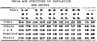
| Q.8. |
Study the table given below and name the two states (i) one
which has the highest percentage of male population in the age group
of 15 - 29 years and (ii) the other having the highest percentage of
female population in the age group of 60 years and
above. Compare these figures with those of India as a
whole and draw appropriate conclusions.
|
| Ans. |
(i) The state having the highest
percentage of male population in the age - group of 15 - 29 years is
Nagaland (15.99). (ii) The state having the highest
percentage of female population in the age group of 60 years and
above is Kerala (3.98%).
In the first case, the percentage
of male population in India as a whole (in the age-group of 15-29
years) is 13.34 % which is below 15.99 % (Nagaland). The male
population in this tribal area is quite high ( though at a medium
level). It is because of low status of women higher incidents
of masculinity at birth in -migration of males for employment
purposes and in-migration of armed forces in border districts.
In the second case, the percentage
of female population in India as as a whole (in the age-group of 60
and above) is 3.18 %. The female population above 60 years of
age is still high because of low fertility and low mortality rates
and may because of low fertility and low mortality rates and may be
because of male out-migration for employment to other places.
The other major reason can be high literacy rate in kerala and high
level of awareness. |
| Q.9. |
Keeping the given below outline map as the base draw a sketch
map of National Capital Region in your answer - book and show
therein, the following towns : |
| 9.1 |
Meerut |
| 9.2 |
Palwal |
| 9.3 |
Gohana |
| 9.4 |
Ramgarh
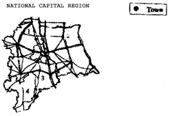
|
| Ans. |
1. Gohana, 2. Meerut, 3. Palwal 4.
Ramgarh |
| Q.10. |
Name serially the six geographical features marked in the
given map with numbers 1 to 6 in your answer - book :
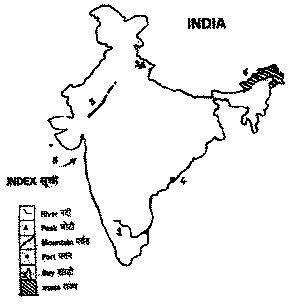
|
| Ans. |
1. R. Cauvery, 2. Nanda Devi
3. Aravalli Range 4. Vishkhapatnam, 5. Bay of Khambat 6. Arunachal
Pradesh |
| Q.11. |
Which one of the given three graphs - A,B and C, depicts the
climatic data of Delhi ? Give one reason each with reference to (i)
temperature, and its range, (ii) amount of rainfall and (iii)
Rainfall regime in support of your answer in selecting the graph.
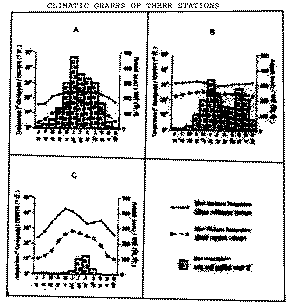
|
| Ans. |
Graph 'C' depicts the climate data
of Delhi. |
| Q.12. |
What is meant by 'Regions of Second Order'? Describe three
main characteristics of the Himachal and Kumaon region.
|
| Ans. |
The first order or (Macro) regions
are further sub-divided into 'Regions of Second Order' or
micro-regions due to the local physiographic, geomorphic, climate,
vegetal and soil difference within the same broad region.
Three main characteristics of the
Himachal and Kumaon region are : The mountain ranges of the
Himalayas and the Kumaon lie to the east of the Satluj gorge (i) The
relief of this region is not different from the Kashmir Himalayas,
Numerous mountain peaks like Kedarnath, Nadrinath and alakhnanda
supply water to several rivers.
(ii) Climate varies with rise in
attitude. Annual temperature varies between less than 0
deg. C in winter and 21 deg. C in summers. Rainfall
decreases from east to west and from south to north. Kangra
Valley records annual rainfall of 250 cms, Kullu valley 100 cms and
Shimla 160 cms. People migrate from plains to the hill in
summer to escape the scorhing heat of the plains.
(iii) Natural vegetation in dense
but it varies depending upon the attitude. The people here are
engaged in agriculture. Wheat, rice and barley are
grown. Potato and (tea also) is cultivated. Some
lead a nomadic life and some rear animals. |
| Q.13. |
Name the three types of rural settlements found in
India. Discuss two major characteristics of each type.
|
| Ans. |
The three types of rural
settlements found in India and features of each : (i)
Clustered ( agglomerated or nucleated) : These are found in
fertile plains and valleys. The houses here are compact having
narrow, winding streets separating the two rows of houses.
Sometimes such settlements have a definite layout plan which may be
linear rectangular, L-shaped or shapeless.
(ii)
Semi - clustered (partially agglomerated) : These
settlements have a small but compact nucleus around which the
hamlets are dispersed forming a ring around the main
settlement. If the houses are situated along a road the
settlement looks like a nuclear cluster.
(iii)
Dispersed : Here hamlets are scattered over a vast
area. There is no specific plan and the settlement unit is a
single hamlet. These settlements are on mountaineous and arid
regions. |
| Q.14. |
Distinguish between ferrous and non-ferrous minerals by giving
suitable examples. Let your answer contain four points each.
|
| Ans. |
Minerals are of two type - metallic ( such as iron
ore and copper) and non-metallic (such as limestone and dolomite0
Metallic minerals are further sub-divided into ferrous and
non-ferrous minerals. The minerals which contain iron-ore are
known as ferrous minerals (like iron ore, magnesium and
bauxite). The minerals which do not contain iron - ore are
non-ferrous minerals such as copper, lead, zinc and so on.
|
| Q.15. |
"The triple transport system plays an important role in
strengthening the social, political and economic unity of
India." Elaborate all the four elements in this question
by giving a suitable example of each. |
| Ans. |
The importance of an effective
triple transport system can not be over - looked. A good and
well-organised transport by land, water and air is one of the
pre-requisites of the prosperity - social, political and economical
of a nation. Transport system helps the nation utilize
its economic resources and it is also essential for the rapid
industrialisation of India. The efficiency of transport
depends on its dependability, reliability and cheapness. The
means of transport, no doubt, are called the lifelines of a nation
and its economy. The Central Government controls
National Highways and railways directly. They link leh
(J&K) and Kanya Kumari (Tamil Nadu) and saidya (Assam)
and okhla (Gujarat). Means of transport carry foodgrains
and various manufactured goods to various places. They bring
industrial raw materials at industrial sites. They help
integrate the nation as people of one region visit other parts of
the country and have a social interaction. This helps
strengthen feelings of fellow - feeling and
brotherhood. The transport system has tuned local
markets of yesteryears into national markets of today. Air
transport has made it possible to reach the remotest corners in no
time. The development of the means of transport has led to the
commercialisation of agriculture, manufacturing of goods, growth of
towns and cities and increase in the mobility of people. Thus,
it has been rightly said that the triple transport system
plays an important role in strengthening the social, political and
economic unity of India. |
| Q.16. |
What are the factors responsible for the social unity in India
? Explain any five with suitable examples.
|
| Ans. |
There are various factors
responsible for the social unity in India. The
horizontal spread of cultural and social-economic attributes from
different parts of the country generate cultural fusion. This
is because of the leanings through Sanskrit, Persian and
English. The Vedic and Puranic influences are uniformly
witnesses in social life. The preachings of Bhakti and Sufi
saints to achieve brotherhood had influenced rural India, especially
during the Medieval period. The development of inter -
regional economic connections and emergence of a national home
market in the modern period has led to this unity. The role played
by the Himalayas as wind barrier provides climatic unity. The
seasonal \rhythm of monsoons is an all India phenomenon. Rain
is welcomed throughout. Fok songs and music are associated
with monsoonal rains. Establishment of an effective transport
system and communication network has helped develop and strenghten
bonds of social unity.
The caste system of India has a
tremendous impact or social life. No doubt, religious beliefs
constitute an important elements in the spiritual life of people,
but religious sects are inter-lived with each other. Holy
places are visited by all religious communities. Thus, all
this helps strengthen the bonds of social integration in
India. |
| Q.17. |
Explain four important factors responsible for the development
of Bihar - Bengal industrial cluster. Describe location and
extent of this cluster. |
| Ans. |
Four important factors responsible
for the development of Bengal - Bihar Industrial cluster and the
location and extent of this cluster. This industrial cluster
(Chota Nagpur Plateau industrial cluster) is surrounded by highly
populated states of Bihar, Orissa and West Bengal which provide
cheap labour. This cluster owes its development
to the discovery of coal in Damodar Valley and iron - ore in Bihar -
Orissa mineral belt. Power is available from the dam sites in
the Damodar Valley and the thermal power stations based on the local
coal. Cheap labour is provided by Bihar, West Bengal and
Orissa. Calcutta provides a large market for the goods
produced in the Chota Nagpur region. It also provides the port
facility to the region. It has the advantages for developing
ferrous metal industries. The Tata Iron and Steel Company,
Indian Iron and Steel Company, Hindustan Steel Limited at Durgapur
and Bokaro are some of the important steel plants located
here. Heavy engineering, machine tools, fertilizers, cement,
paper, locomotives and heavy electrical are other important
industries here. Important nodal centers are Ranchi, Dhanbad,
Chaibasa, Hazaribagh, Daltanganj, Sindri, Garwa, Jalpa and
Jamshedpur. |
| Q.18. |
Explain five main non-geographical factors influencing the
location of industries by giving suitable examples from Indian
industries. |
| Ans. |
(a)
Markets : Markets should be near by the Industries and
accessible too. If the markets are far away, the cost of
the finished foods becomes high. The size of the market and
purchasing capacity of the customers are also important
factors. Several big towns such as Calcutta and Kanpur
have cotton mills as markets are quite near by. The agro-based
industries and industries that produce goods for daily use are set
up around big cities. (b)
Availability of investment capital is also important.
(c)
Advantages of an early start : Such as cotton industry of
Maharashtra and Gujarat and jute mills of West Bengal were set up
during the British period. The Bitishers provided the
necessary machines and technical skill. hence, the skill that
labour acquires through long association with industry and the
tradition it leaves behind make an industry persist there as the
skill is passed on from generation to the other.
(d) The industrial policy of our
government is based on the economic development of the country,
elimination of pollution and avoiding congestion in big
cities. Various industries in public sector and small scale
industrial sector have been established in those areas which are
deficient in industrial development. |
| Q.19. |
On the outline map of India, provided to you, locate and label
the following : |
| 19.1 |
A major river, originating from Mansarover region and flowing
towards west. |
| 19.2 |
An area of moist tropical evergreen vegetation in peninsular
India. |
| 19.3 |
Telugu speaking state. |
| 19.4 |
The first nuclear power station set-up in India.
|
| 19.5 |
The largest oil refinery in India. |
| Ans. |
Consult a good atlas. See
the answer below : |
| 19.1 |
Sindhu / Satluj |
| 19.2 |
Rainy tracts of the Sahyadris and
hilly regions of the Shillong Plateau. |
| 19.3 |
Andhra Pradesh |
| 19.4 |
Tarapur |
| 19.5 |
Digboi ( Assam) |
| Q.20. |
For Blind Students only ( in lieu of Q. Nos. 9,10,11 and 19)
Explain
the following topics in about 100 words each :
|
| 20.1 |
The Malwa Plateau |
| 20.2 |
Onset of monsoon |
| 20.3 |
Retreating monsoon season |
| 20.4 |
East Himalayan agro - climatic region
|
| 20.5 |
Planning region |
| Ans. |
20.1 The Malwa Plateau : River Narmada flowing from east
to west divides the Great Plateau into two parts : The Malwa Plateau
and the Deccan Plateau. The north of the river Narmada as the
Malwa Plateau. It is surrounded by the Aravallis in the
north-east and the Vindhyas in the south. The third side of the
Plateau slopes towards the Ganga - Brahmaputra plains. The
Plateau extends from west to east. its further
extensions are Bundelkhan, Ruhelkhand and Chota Nagpur, Bundealkhand
and Ruhelkhand are in Southern Uttar Pradesh and Chota Nagpur is in
Southern Bihar. |
| 20.2 |
Onset
of monsoon : With the northward shift in the position of
the sun, the himalayan and the Tibetan highlands are excessively
heated. This leads to be clockwise circulation in the
middle troposphere. The two main streams of air flowing out of
this landmass take opposite directions. One of them moves
towards the Equator, and the other one moves towards the pole.
The Equatorial flow from these highlands prevails over India as the
Easterly jet stream and it replaces the air that crores the equator
and reaches the west coast of India as South - West
monsoon. This engulfs the entire sub-continent July
15th. It sets in over the Kerala coast by 1st June and moves
to Bombay and Calcutta between 10-13th June. |
| 20.3 |
Retreating monsoon season : The south - west monsoon
begins to retreat from northern India by the second week of
September. This retreat is highly gradual. This
retreat also shows regional variations . The weather is
characterised by high day temperatures but nights are pleasant with
the mean minimum temperature going down to 20 deg. c or even
lower. The diurnal range of temperature is more
pronounced. several cyclonic storms develop in the Bay
of Bengal, which move in a south - easterly to north - westerly
direction. The cause heavy rainfall on the eastern
coast. It withdraws itself fully from the region, except the
southern Peninsula by mid October. The retreating monsoon
picks up moisture from the Bay of Bengal and establishes itself over
the Tamil Nadu coast as the north - east monsoon. |
| 20.4 |
East
Himalayan agro - climatic region : India is an agricultural
country and development of this sector is very important for an
overall development of the economy. The country has been divided
into 15 agro-climatic zones on the basis of homogeneity in factors
like soil type, rainfall, temperature, water resources. One of
them is Eastern Himalayan agra - climatic region. The main
objectives are to bring about a balance in demand and supply of
major commodities by utilising the potential of each of them;
maximise the net income of the producers; generate additional
employment and provide the framework for substantial use of natural
resources, especially, land, water and forests - a more scientific
utilisation of resources to realise the unexploited potentials.
|
| 20.5 |
Planning region : A planning region is a segment of
territory over which the economic development may be done on the
pattern of planning. A planning region is generally based on
the statistical data and it is collected by the administrative
units. A planning region coincides with the
administrative region such as State, Districts, Tehsils and
Block. A planning region should have certain features in order
to implement the economic plan and get its objectives
fulfilled. It should have homogeneous economic structures
(topographical and socio-cultural
homogeneity). |
