|
CBSE ANNUAL PAPER - 1998
GEOGRAPHY
(SET-I)
Time Allowed : 3 Hours
Maximum Marks : 70
General Instructions :
(i)
All questions are compulsory.
(ii)
Marks for each question are indicated against
it.
(iii) Question numbers 1 to 8 are
short-answer questions carrying 3 marks each.
Answer of each of these questions should not
exceed 80 words.
(iv)
Questions numbers 11 to 15 are also short -
answer questions of 4 marks each. Answer of each
of these questions should not exceed 120 words.
(v)
Question 16,17 and 18 are long - answer
questions of 5 marks each. Answer of these
questions should not exceed 150 words.
(vi)
questions 9, 10 and 19 contain test items of
very short-answers i.e., answers varying from
one word to a couple of sentences. Q. 9 and 10
are of 3 marks each and Q. 19 is of 5 marks.
(vii) Outline map of INDIA provided to you
must be attached with you answer - book.
(viii) Use of templates or stencils for
drawing outline maps is allowed.
(ix)
Question numbers 9,10 and 19 are not for BLIND
STUDENTS, but in lieu of these question number
20 is provided for them.
(X)
Question No. 20 is for BLIND STUDENTS ONLY.
|
| Q.1. |
"The House in its design or internal
plan reflects the social and cultural values of
our people." State three facts which
support the above statement.
|
| Ans. |
Following facts is given
below in support of the above statement :
(i)
The design of the house itself shows the social
status of the owner of the house. For e.g. a
rich man having good social status and belongs
to advance culture builds his house with burnt
bricks, cement and concrete, such house has many
rooms and spacious courtyard, it has double or
even triple stories. Such houses are found in
Western U.P., Haryana and Punjab where the
farmers are rich and advanced.
(ii)
The house of socially and culturally backward
poor people is a single but with a single or
double slope roofs. It has space for storing
grain and for livestock and a room for the
kitchen. The space in front is used as
courtyard. Such houses are found in those
regions where the shifting cultivation is still
practised and where the village economy is still
dependent on collection from the forests.
(iii) A characteristic feature of the
Indian house type is the courtyard ( angan or
uthan). It is universal. It is here the family
performs most of the functions of their
household. It is the main living space, for
storing property, for privacy and for sleeping
in winters. The courtyard has its varieties in
the form of a porch or an overhanging verandah
as an extension of the main house in the cold
and wet highland regions of Jammu and Kashmir,
Himachal Predesh, North East, Nagaland, etc.
|
| Q.2.
|
Which racial group is the architect of the
Indus Valley Civilisation ? Name its three
subgroups. Which subgroups forms the bulk of the
population in southern India ?
|
| Ans. |
The Proto - Austratoids are
believed to be the builders of the Indus Valley
Civilisation as their skeletons have been
discovered in Mohenjodaro and Harrappa. The
Mediterraneans developed the Indus Valley and
introduced the bronze and metal civilisation.
The
three sub-groups of the Mediterraneans are :
Palaeo-Mediterraneans, Mediterraneans and
Orients.
The
Palaeo-Mediterraneans sub - groups today forms
the bulk of the population of southern India.
|
| Q.3. |
How
is the peninsular shape of our country helpful
to us ? Give three reasons.
|
| Ans. |
The reasons are :
1.
India is situated in the centre of the Indian
Ocean . The Indian Ocean has been helpful,
though earlier it was regarded as an impediment,
in establishing her contacts both commercial and
cultural with the South Asian, South West and
South East Asian countries.
2.
It has centrally located position with regard to
Mediterranean lands of Europe.South - West Asia,
South -Eat Asia and far East. The opening of
suez Canal has brought closer to the countries
of Europe and North West Africa. It has come
close to far East such as Japan, Hongkong and
China through Malaccan Strait. The oil producing
countries of West Asia and Gulf countries are
close to its West.
3.
Hence, India enjoys a central position in the
eastern hemisphere. Ships from West to far cast
has to pass through the Indian Ocean. The far
eastern countries following sea routes of
Malaccan Strait and Suez Canal have to pass
through the Indian sea waters. Hence, India
enjoys the most central position in the Indian
Ocean. |
| Q.4.
|
"Unity in diversity is the major
feature of India." Explain the above
statement by giving three examples from the
major religions of India.
|
| Ans. |
Unity and diversity of India
are not opposites capable of growing at each
other's cost. They are inter-linked and the one
supports the other. This is the verdict of
India's history and geography alike. This is
basically wrong to say that Indians belong to
sixx racial groups and nine sub-types. One can
find all or some of these traits even in a
single family. Actually, Indians are either
vegetarians or non-vegetarians or godly or
demonic in temperament as else where in the
world depending largely on their food habits.
Yet they are one united nation living under the
same monsoonal region. Language, the means of communication, is
the most important manifestation of the social
cohesion of a group. Linguistic diversity in
India reflects regional differentiation, on the
one hand and is an important factor in the
formation of regions, on the other. The
magnitude of linguistic diversity in the country
has been over-stated. Only 23 out of 187
languages of India account for 97 % of the
population. The regional structure as shown in
the distribution of major languages is
hierarchical in nature dialect regions nesting
into sub-language regions, into language regions
into linguistic family regions. The basic unit
in the folk ethos is the dialect region which
has persisted over long periods. The link
between the language and the territory is
brought out effectively by the fact that the
local dialects have been, since ancient times to
the present, designated by the geographic names
of territories where they are spoken for e.g.
Avanti, Prachaya, Bhojpuri, Dakhshinatya ,
Awadhi, Bundeli, Savraseni, and Natya Shastra.
As Vidyalankar says, "The areas of Indian
dialects and languages, as they are found today
correspond with the ancient and medieval
janpadas or janpadasanghas. They have grown out
of the whole history of India." As we move
to the higher levels of languages, we come
across the four - fold regional division : (i)
the Dravidian region of the South (ii) The Indo
- Aryan region of the North and North - West,
(iii) the Monkhmer and the Tiobeto Mayanmar
region of the North - East and the Himalayas,
and (iv) The Austric region of the Aravalli
Vindhya Chottanagpur plateau complex. As katre
says, " Achemical fusion not a physical
mixture where the different components can be
easily separated. During the last three thousand
years. each of these distinct group of languages
has come into close contact with the remaining
groups, and out of this contact has arisen a
vocabulary which shows a Pan-Indian
characteristic". Thus, language have played
a significant role in the process of national
integration in the recent India. For e.g.
Hinduism is a mixture of Hindi and Urdu us
understood in all parts of India.
|
| Q.5. |
Which type of soils are derived from Deccan
Lavas ? Explain two important characteristics of
these soils.
|
| Ans. |
Black soils are derived from
Deccan Lavas. The three important
characteristics of these soils are :
(i)
These soils are formed by Java. These soils are
also referred to as cotton soils or Regular
soils, because cotton is the most suitable for
cultivation. These soils formed by the
solidification of lava spread over large areas
during volcanic activities thousands of years
ago on the Deacon plateau, Maharashtra, Madhya
Predesh, Gujarat, Tamilnadu and Coromandel
coastal plains and Andhra Pradesh are the major
areas of Black soils.
(ii)
Those soils are deep and impermeable. These
soils are clayey and capable of sustaining
moisture for long time. In dry and hot season
moisture is evaporated and they develop cracks.
During rains they become sticky.
|
| Q.6. |
Proportion of Scheduled Tribes &
Scheduled Castes, 1991
|
|
|
States/ Union Territories
|
Percentage of Scheduled Tribes Population
|
Percentage of Scheduled Castes Population
|
| 1 |
Arunachal
Pradesh |
63.66 |
0.47 |
| 2 |
Haryana |
-- |
19.75 |
| 3 |
Himachal
Pradesh |
4.22 |
25.34 |
| 4 |
Lakshadweep
|
93.15 |
-- |
| 5 |
Meghalaya
|
85.33 |
0.51 |
| 6 |
Mizoram
|
94.75 |
0.10 |
| 7 |
Nagaland
|
87.70 |
-- |
| 8 |
Punjab
|
-- |
28.31 |
| 9 |
Tamil Nadu
|
1.03 |
19.18 |
| 10 |
Uttar Pradesh
|
0.21 |
21.05 |
| 11 |
West Bengal
|
5.59 |
23.62 |
|
|
Study carefully the table given above and
then answer the following questions :
|
| 6.1 |
Which are the four States / Union
Territories leading in the percentage of
Scheduled Tribes population ?
|
| 6.2 |
What
is the position of these States / Union
Territories in the percentage of Scheduled
Castes ?
|
| 6.3
|
What
conclusion can be drawn from the answers to the
above two questions ? Suggest one reason for the
same.
|
| Ans. |
|
| 6.1 |
The four Union Territories
leading in the percentage of the scheduled
tribes population are Mizoram (94.75),
Lakshadweep (93.15), Nagaland (87.70) and
Meghalaya (85.53). |
| 6.2 |
The position of these Union
Territories in the scheduled castes population
is very -very low and even nil. In Lakshadweep
and Nagaland the percentage of the scheduled
castes population is nil Meghalaya has 0.51 and
Mizoram has 0.10 % of the scheduled castes
population which is very - very low as compared
to the other regions.
|
| 6.3 |
The Union Territories
(Lakshadweep, Meghalaya, Mizoram and Nagaland )
have the highest percentage of the scheduled
tribes population. The reasons are many. The
tribal population inhabit mainly the regions of
low degree of accessibility and the areas which
are unfavourable for agriculture. That's why
they've a tendency of clustering and
concentrating in the hilly and forested tracts
of the country. These areas are socially and
economically less advanced but they are rich in
natural resources such as forests and minerals.
The tribals have distinct cultures.
|
| Q.7.
|
AREA, PRODUCTION & YIELD OF SELECTED
CROPS
|
|
| Crops |
Area ( in lakh
hectares) |
Production (in lakh
tonnes) |
Yield ( in kg. per
hectare) |
1950-
51 |
1993-
94 |
1950-
51 |
1993-
94 |
1950-
51 |
1993-
94 |
| Jowar |
156 |
120 |
55 |
115 |
363 |
894 |
| Tea |
3.14 |
4.0 |
275 |
7.6 |
87.6 |
1900 |
| Cotton |
59 |
73 |
31 |
107 |
89.3 |
248 |
|
|
Study carefully the table given above and
answer the following questions :
- |
| (7.1) |
What
is the proportionate increase in the production
of JOWAR during the period 1950-51 to 1993-94 ?
|
| (7.2) |
Which item given in the table is mainly
responsible for the increased production ?
|
| (7.3) |
Suggest one reason for the decline in the
area under JOWAR during the period 1950-51 to
1993-94.
|
| Ans. |
|
| (7.1) |
There is a proportionate
increase in the production of Jowar during the
period 1950-51 to 1993-94. During 1950-51 the
production of Jowar was 55 lakh tonnes and it
has increased to 115 lakh tonnes during 1993 -
94. The increase in the production of Jowar has
been almost two times as compared to the
production during 1950 - 51.
|
| (7.2) |
Yield of Jowar is mainly
responsible for the increased
production. |
| (7.3) |
Jowar is a coarse grain. It
is grown both as Kharif and rabi crops. But it
has been lagging behind in area ( under Jowar).
It is an important grain for poor rural Indians.
A vast part of the cultivates land is rainfed,
therefore, there is need for stabilising the
level of production. This is possible through
adopting dry-farming techniques, conservation of
soil moisture and water shed management. A
number of projects are being undertaken to
enhance its production.
|
| Q.8. |
Discuss the trend of urbanisation with
special reference to post-independence India,
citing three examples.
|
| Ans. |
| Year of Census
|
Urban Percentage
|
| 1901 |
10.84 |
| 1911 |
10.29 |
| 1921 |
11.17 |
| 1931 |
11.99 |
| 1941 |
13.85 |
| 1951 |
17.29 |
| 1961 |
17.97 |
| 1971 |
19.90 |
| 1981 |
23.31 |
| 1991 |
25.70 |
|
|
Study the table given above and then answer
the following questions :
|
| 8.1
|
At
the turn of century only one person out of every
nine or ten was a city dweller. Using this same
layman's language how will you explain in a
single sentence the position of the urban
population as obtained in 1991 ?
|
| 8.2
|
Compare very briefly the trend in the
growth of urban population between 1901 and 1961
with that of 1961 and 1991.
|
| Ans. |
|
| 8.1 |
Thus means that more and
more people are moving towards the urban centres
in search of better jobs and better amenities of
life. This is why, there is an increased in the
percentage of urban population (25.70 %) in
1991. This has also created the problem of
housing and unemployment.
|
| 8.2 |
The growth of urban
population is very strong in India. In 1901 the
agriculture had reached near saturation points,
the villagers began to move towards urban
centres from villages in search of better jobs
and livelihood. Since then, there has been an
increase in the urban population of India.
According to the census about 157,68 million
people live in urban areas. In India in 1901,
the percentage of urban population was 10.84.
The largest number of urban people has been
living in industrial towns. It has become 23-30
in 1981. Within a period of 80 years it has
increased by 12.46 %. According to 1981 census,
about 157.68 million people live in urban areas.
The non-agricultural labourers, educated people
and mostly male members are the parts of this
population. According to 1961, the urban
population percentage was 18 %. The urban
population is concentrated in highly economic
developed stages. For instance, Punjab is the
most urbanised stage among the inland states of
India. It has about 27.68 of urban population.
|
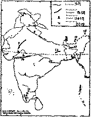
| Q.9. |
Write the names of the relief and drainage
features marked in the map given below by
1,5,10,13,15 and 18.
|
| Ans |
The names of the relief and
drainage features marked in the map given are :
1.
- River Indus
5
- River Mahanadi
10
- Satpura Range
13
- Khasi Range
15
- Namacha Barwa
18
- Kanchenjunga |
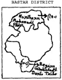
| Q.10. |
Keeping the given outline map as base,
draw a free hand sketch - map of Bastar distric
in your answer - book, and in it mark and label
:

|
| 10.1 |
Northern Mahanadi
Plain; |
| 10.2 |
Region inhabited by Dorla tribe
|
| Ans. |
|
| Q.11. |
Describe four methods of conserving water
resources.
|
| Ans. |
India is land of vast and
varied natural resources such as vast cultivable
soil, water, ground water, forest, animal and
fodder, fish and marine, mineral, energy and
human resources. Our predecessors as well as
successors alike had and have claims over
India's natural resources which at the present
rate of exploitation may not last long. Hence
the urgent need for natural resource
conservation so that the tempo of national
economic development may never suffer a set
back. For soil conservation judicious use of
fertilisers and manures, rotation of crops,
plantation of crops of leguminous variety, soil
protect on against weathering and denudation
contour ploughing, preservation of vegetation
cover and protection against overgrazing are
necessary. There should be soil reclamation
also. For conservation of water resources there
should proper water management, scientific means
of irrigation, etc. The forest cover of India is
far below the minimum level of 33 per cent of
all land area. The actual forest cover of India
is one of the lowest in the world. It is less
than 11 per cent. This has led to land sliding
particularly in the attachment areas of the
rivers and soil gulling and luiching in the
river valleys and plains of India. This has to
be avoided. There should be rapid afforestation
of river banks and alluvial plains and flanking
bill slopes with indigenous trees and not fast
growing exotic trees, otherwise India's rainfall
regime will be spoilt beyond cure and the goal
of 33 per cent forest cover must be achieve at
the earliest possible date. Due to thoughtless
afforestation with eucalyptus trees India's
ground water level has gone down at an alarming
rate. The author had force warned Smt. Indira
Gandhi against it, but in vain. India is quite
rich in some mineral resources such as coal,
petroleum, iron ore, manganese, bauxite,
commercial clays, thorium etc. and deficient in
such minerals as tuagsten, nickel, silver, gold
molybdenum, Zinc, copper uranium, beryl, cobalt,
chromium etc. Hence substitutes of dencient
minerals have to be discovered and export of
industrially important minerals such as iron ore
and manganese, should be either stopped or at
least reduced to minimum.
|
| Q.12. |
State two characteristic features each of
'Western Himalayas' and 'Gangetic Delta'.
|
| Ans. |
Western Himalayas : - They extend
west of 80 deg. E longitude between the Indian
and Kali rivers. These regions have a weak
monsoon current, i.e. they receive an average
annual rainfall of less than 200 cms. Alpine
vegetation and coniferous trees are found
because they have a high attitude.
Gangetic
Delta : The Ganga delta marks the tail
end of the North India Plain. This world's
largest deltaic plain is conspicuous by its
image of river courses which actually are the
distributaries of the Ganga with Hoogly forming
its western boundary and the Kali its eastern
boundary in India, while in Bangla Desh the
boundary of the Ganga Delta extends to the river
Meghna. This is a plain of fine grained alluvium
or heavy loams with a high humus content
overgrown with Sundari plants a variety of
dipterocarpace. Here rainfall is heavy and
annual temperatures have a low range. This area
is quite rich in wild life as district from the
richness of domestic animals in the Punjab
Plans. |
| Q.13. |
|
| 13.1
|
What is the notion of development in the
context of regional development ?
|
| 13.2
|
Name the three parameters of development.
|
| 13.3 |
For each parameter, explain in one
sentence only, how it influences development.
|
| Ans.
|
|
| 13.1 |
The notion or the idea of
development in the context or regional
development refers to a concept which aims at
upgrading the living standard of people and
condition of human welfare in a region. it
increases the per capita income of that region.
But the parameters of development differ from
region to region. That's why some regions are
more developed than the other. This leads to
social as well as regional diversities.
|
| 13.2 |
The three parameters of
development are : (a) Natural environment (b) Technology and
(c) Institutions |
| 13.3 |
(a) Natural environment - It gives
the direction of economic development and it
limits the area of development. (b) Technology - It limits the extent
of production. Human beings interact with
natural environment through technology.
(c) Institutions - They enhance the
economic development of region. They should be
dynamite in nature so that they may be
transformed or modified with the changing time.
|
| Q.14. |
"Agriculture development in some
regions of India is higher than in others."
Give four reasons for the above statement and
illustrate with examples.
|
| Ans. |
Agriculture labour migrates
seasonally from Bihar to Punjab specially
because Bihar is land of too many natural
hazards and God sent calamities such as flood,
famine and drought while punjab is an area of
surplus production. Secondly, the per capita
income of a Bihari is among the lowest while
that of a Punjabi is among the highest in India.
Thirdly, the southern parts of Bihar are quite
inhospitable because of mountains terrain,
forests, proneness to malaria, and other
epidemics, transport and travel difficulties.
But Punjab has throughout fertile soils and has
got excellent irrigation facilities. The
punjabis are very hard working and the farm
implement factories are dotted here and there in
the state. Even then the sowing and harvesting
seasons if Punjab are labour intensive, while
the Punjabis outnumber people from other states
in the army services and factories its northern
India while the members of their Bihari
counterpart art quite low. So on account of
their poverty, dearth of lock employment
opportunities on one hand much demand of farm
hands in Punjab at the harvesting and sowing
times on the other causes seasonal migration of
agricultural labour from Bihar to Punjab inspite
of terrorist menace. |
| Q.15. |
Study the climatic data given on next page
and answer the following questions :
|
| 15.1 |
Which station has the lowest mean annual
range of temperature ? Why ?
|
| 15.2 |
Why does Delhi receive less annual
rainfall than Bombay (Mumbai) ?
|
| 15.3 |
Compare the rainfall regimes of Bombay
(Mumbai) and Madras (Chennai).
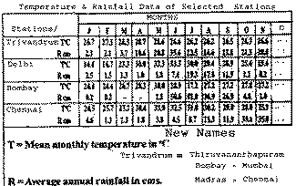
|
| Ans.
|
|
| 15.1 |
Trivandrum has the lowest
mean annual range of temperature of 2.5 deg. C
and Trivendrum is a coastal area which doesn't
register any significant seasonal changes in
temperature. The influence of sea keeps them
with equable temperature. Temperature of
Trivendrum fluctuates very slightly. Sea gets
heated and cooled down slowly because of
conventional processes of heating and cooling
and hence they remain warmer in winter and
cooler in summers, keeping the coastal area
equable in temperature. The warm ocean currents
also keep this area with equable temperature
throughout the year. |
| 15.2 |
Delhi receives less annual
rainfall than Bombay ( Mumbai) because of its
deep continental situation as it is far removed
from the sea at an attitude of over 600 ft. near
the margin of the Great Indian Desert.
|
| 15.3 |
The Madras Coastal region
lies on the eastern side of the Western Ghats.
During summer, in Arabian sea South-West
monsoon-branch strikes against the Western Ghats
and false its maximum moisture on the western
side of the Ghats. Hence, the Madras region
remains dry. During winter, the North-East dry
monsoon blow from the Central Asia toward Bay of
Bengal, they pick up the moisture and bring rain
(30.6 cm, 35cm etc. ) to this area. The
retreating monsoon picks up moisture and
establishes itself over Madras as the North-East
monsoon. Bombay - The distribution of annual
rainfall in India is controlled by the relief
features. Because of this reason, the highest
amount if rainfall occur on The Western Chats
Bombay falls in this area and it is near the
Sea, so its gets the highest amount of rainfall.
It decreases with the increasing distance from
the sea. This region get rainfall at the onset
of the monsoon. |
| Q.16. |
Describe five important factors helping in
the development of apple orchards in Himachal
Pradesh.
|
| Ans. |
The introduction of apple
orchard was started in 20th century. Apple grows
in temperate regions. Apple gardens are planted
over mountain slopes. The main areas are shimla
and Kulu. There is about 4 lakh tonnes of apple
production in Himachal Predesh. There is great
demand of apples in towns. Due to increase in
demand more farmers are needed. thus there is an
increase in the salary of the farmers and there
is more scope of employment to unemployed
youths. There are also H.P.M.C. stalls of apple
juice at railway stations. The main varieties of
apple in Himachal Pradesh are - Red Delicious,
Beauty of Bath. Early Shaburry, Golden delicious
red, etc. Due to these apple orchards the
economic condition of Himachal has improved
quite a lot because of high -yielding varieties
which increase the production and produce more
money and foreign currency. The introduction of apple orchards in
Himachal is indicative of a strategy of
agricultural growth. Himachal produces wheat and
millets and pulses. Mittets are low value crops.
They are replaced by high-value crops. Apple
orchards have replaced the millet crop. Apple is
a nutritive fruit and is in great demand in
urban areas. Its cultivation has increased the
income of the farmers and has generated
employment in packing, picking and processing of
apples and helped the wage labour to earn a
little higher wages.
|
| Q.17. |
|
| 17.1 |
State two facts which have helped in the
growth of industrial clusters.
|
| 17.2 |
Describe three factors which have helped
in the industrial development of Ahmedabad -
Vadodara industrial region.
|
| Ans. |
|
| 17.1 |
Industrial location depends
upon geographical as well as non-geographical
factors. While geographical factors include
availability of raw-materials, power, congenial
climate, abundant water supply etc., the
non-geographical factors are (i) Capital (ii)
efficient management (iii) nearness to market
(iv) government policy and (v) historical
factors |
| 17.2 |
The three factors
contributing to the development of Ahmedabad -
Vadodra Industrial Region :
This Industrial Region has inland
location. This belt extends between Ahmedabad -
Vadodra and Bharuch and coincides with the
cotton - growing areas of Gujrat.
(i) This region is located near the cotton
growing areas of Gujarat.
(ii) It has the advantage of the esay
availability of raw material sources and
marketing centres of Ganga and Sutlet plains.
The port of Kandla provides the facilities of
export and import.
(iii) Cheap labour and cheap land for
expansion are available from the densely
populated areas of Ganga plain. The discovery of
mineral oil in the gulf of Combay led to the
establishment of Petro-chemicals complex around
Vadodra and Ankleshwar. There are also textiles,
pharmaceuticals and food processing industries.
Ahmedabad, Surat, Bharuch and Vadodra are
important industrial centres of this region.
|
| Q.18. |
"Road transport in India is not
competitive but complementary to rail
transport." Explain this statement by
giving five arguments in its support.
|
| Ans. |
Roads play a very important
role in the movement of goods and passengers in
India. The reasons are many. It is comparatively
easy and cheap to construct roads. The
investment is much less on roads. Negotiable
goods can be brought to outdoor steps which is
not possible with the railways. The roads act as
feeders of railways. They link up the
cultivator's holdings with the local markets and
the nearest railway stations. Without good
roads, railway can;t collect sufficient produce
to make their operation possible. Perishable
goods like vegetables and fruits are transported
more easily and quickly than the railways. Road
transport is more flexible. Trucks and buses can
be used at any time and at any place unlike in
the railways. This is the reason why road
transport in India is considered more useful
than rail transport. |
| Q.19. |
On
the outline map of INDIA provided to you, locate
and label the following correctly :
|
| 19.1 |
Highest mountain peak of Peninsular
India. |
| 19.2 |
River on which Hirakud Dam is
located. |
| 19.3 |
Capital of Union Territory whose divisions
are located both on the eastern and western
coasts of India.
|
| 19.4 |
A
State which heralded the Green Revolution.
|
| 19.5 |
A
spacious natural harbour, shared by two major
ports of
India. |
| Ans. |
|
| 19.1 |
Anai Mudi (695
mts.) |
| 19.2 |
Godawari
River |
| 19.3 |
Pondicherry |
| 19.4 |
Gujarat |
| 19.5 |
Bombay
(Mumbai) |
|
[
For BLIND STUDENTS only ( in lieu of Q.
9,10,19)] |
| Q.20. |
|
| 20.1 |
Name two mountain ranges located in
eastern India,
|
| Ans. |
|
| 20.1 |
Two mountain ranges located
in eastern India are : Khasi Range and Garo
Range.
|
