|
CBSE ANNUAL PAPER - 2000
GEOGRAPHY
(SET-I)
Time Allowed : 3 Hours
Maximum Marks : 70
General Instructions
:
(i)
All questions are compulsory.
(ii)
Marks for each question are indicated against
it.
(iii) Question numbers 1 to
8 are short-answer questions carrying 3 marks
each. Answer of each of these questions should
not exceed 80 words.
(iv) Questions numbers 11 to
15 are also short - answer questions of 4 marks
each. Answer of each of these questions should
not exceed 120 words.
(v) Question 16,17 and 18
are long - answer questions of 5 marks each.
Answer of these questions should not exceed 150
words.
(vi) questions 9, 10 and 19
contain test items of very short-answers i.e.,
answers varying from one word to a couple of
sentences. Q. 9 and 10 are of 3 marks each and
Q. 19 is of 5 marks.
(vii) Outline map of INDIA
provided to you must be attached with you answer
- book.
(viii) Use of templates or
stencils for drawing outline maps is allowed.
(ix) Question numbers 9,10
and 19 are not for BLIND STUDENTS, but in lieu
of these question number 20 is provided for
them.
(X)
Question No. 20 is for BLIND STUDENTS ONLY.
|
| Q.1. |
"India is neither a pigmy nor a
giant." Elaborate this statement by giving
three suitable
examples. |
| Ans. |
India has quite a large area
on the globe. As far as size is concerned, it is
one of the largest country of the world. It
covers about 3.2 million sq. k. area which is
equal to Europe excluding U.S.S.R. It occupies
the 7th position among the largest countries of
the world and 2nd in Asia next to China. It's
not a small country like Bangladesh, Srilanka,
countries of middle East, South East Africa and
Europe. But, India is not a giant as there are
countries such as U.S.S.R. and U.S.A. which are
bigger than India. U.S.S.R. is 7 times and
U.S.A. is 3 times bigger than India. That's why,
India is neither a pigmy nor a giant.
|
| Q.2. |
Where is the Bhabar land situated in India
? Write its two characteristics.
|
| Ans.
|
Bhabhar : The rivers have
deposited the stones and pebbles at the foot of
the Himalayas where plain starts. This region
which is covered with stones and pebbles is
called Bhabhar. The water flows underground.
After 8 kms. the water of the river flows on the
surface. It makes the surface marshy. It is
called Terai. |
| Q.3. |
Write three differences between the regions
of the First order and the regions of the Second
order.
|
| Ans. |
The first order regions of
India are (also called Macro Regions) : -
(i)
The Himalayan mountain
complex.
(ii) The Indus, Ganga,
Brahamaputra plain. (The Northern
Plain)
(iii) The peninsular Platelau.
The four factors used in
dividing them (first order regions, Macro
regions) into second order regions : -
(i)
Local relief, drainage
(ii)
Animal life and natural vegetation
(iii) Climate and soils
(iv)
Geomorphological history
The macro regions or the
first order regions are quite independent and
distinct from each other. They have a systematic
variation of climate, relief, soils, etc. There
is a broad unity in each region as regards
physical features Relief is the dominant factor
in framing these regions and makes them distinct
from the adjoining areas. These macro regions
are divided into sub-divisions at Micro level
(second order regions). These second order
regions (micro regions) have regional difference
at lower level this difference is found in
relief, soils, etc. and these form the basis of
the sub - regions.
For
Example : -
The Himalayas from one first
order region with a broad uniformity of soils,
natural vegetation and soils, but Western
Himalayas and Eastern Himalayas are separate
second order regions due to distinction in
relief, rainfall, climate, geomorphological
history.
Himalayas : - From East to
West, it can be divided into various distinct
regional units :
(a)
Kashmir Valley
(b)
Karakoram, Ladakh and Balistan
(c)
Himachal Himalayas and Kumaon region
(d)
The Eastern Himalayas
(e)
Purvanchal Hills
These (a) to (e) are second
order regions and the Himalayas is the first
order region but there is difference between
Eastern and Western Himalayas they are the
second order regions of the first order region
(Himalayas but they are different unlike the
Himalayas).
|
| Q.4. |
Suggest three measures to check rapid
population growth in India.
|
| Ans. |
(i) The term growth rate of
population means high birth rate and low death
rate. In this the population grows because the
birth rate is more and the death rate is less.
(ii) India stands on the
fast growth rate of population because the birth
rate is increasing and the death rate is
decreasing.
(iii) In the developed
countries of the world the stage of population
growth is stablized because of low birth rate
and low death rate.
(iv) In order to achieve the
industrialised and urbanized economy the
population policy should be that the birth rate
should be decreased and to decrease birth rate
various steps should be taken. The death rate
should also be decreased with the result
population tends to be stabilized. The size,
distribution and structure of the population
within a country must be viewed in relation to
its natural resources and techniques of
production used by its people.
|
| Q.5. |
State in brief three factors that determine
the type of rural
settlements. |
| Ans. |
Three factors that determine
the type of rural settlements in India are :
|
|
(a) primary occupation, (b)
land based resources, (c) natural environment
factor. |
| Q.6. |
Why
are the scheduled castes mainly concentrated in
the alluvial and the coastal plains of India ?
Give three reasons.
|
| Ans. |
Schedule Castes : - The people who
do service to the under caste, are called
scheduled castes. They are untouchable.
Scheduled tribes belong to Proto - Australoids.
Mangoloids and Negritos. They live in forests
and hilly regions in a great number. They
worship ghosts. (i) States having high concentration :
Uttar Pradesh and Bihar. This is divided into 2
categories : (a) the Indo - Gangetic Plains -
These are composed of rich alluvial soils. Water
supply, suitable climate and weather provide
opportunities for agriculture. The scheduled
castes are primarily agricultural labourers. (b)
The Coastal Plains - The coastal plains provide
identical opportunities for the settlement of
agricultural communities. E.g. Western and
Easthen coasts of Gujarat and Orissa
respectively.
(ii) Sates having medium concentration
: Punjab, Rajasthan and also West Bengal, Madhya
Pradesh, Orissa and Maharashtra.
(iii) States having low concentration :
Jammu and Kashmir and Himachal Pradesh and also
Karnataka, Kerala, Assam, Andhra Pradesh,
Manipur, Meghalya, Tripura, Mizoram, Nagaland.
|
| Q.7. |
Draw
or trace in your answer book the outline map of
Bastar tribal distric as given below and show
therein the following :
(i) Bailadila iron ore mines, (ii) Abhujmar
Hills, (iii) Region inhabited by Parja Tribal
Group and (iv) Region inhabited by Dorla Tribe.
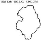
|
| Ans. |
|
| Q.8. |
Explain three factors which are responsible
for regional differentiation and diversities in
India.
|
| Ans. |
Unity and diversity of India
are not opposites capable of growing at each
other's cost. They are inter-linked and the one
supports the other. This is the verdict of
India's history and geography alike. This is
basically wrong to say that Indians belong to
sixx racial groups and nine sub-types. One can
find all or some of these traits even in a
single family. Actually, Indians are either
vegetarians or non-vegetarians or godly or
demonic in temperament as else where in the
world depending largely on their food habits.
Yet they are one united nation living under the
same monsoonal region.
Language, the means of
communication, is the most important
manifestation of the social cohesion of a group.
Linguistic diversity in India reflects regional
differentiation, on the one hand and is an
important factor in the formation of regions, on
the other. The magnitude of linguistic diversity
in the country has been over-stated. Only 23 out
of 187 languages of India account for 97 % of
the population. The regional structure as shown
in the distribution of major languages is
hierarchical in nature dialect regions nesting
into sub-language regions, into language regions
into linguistic family regions. The basic unit
in the folk ethos is the dialect region which
has persisted over long periods. The link
between the language and the territory is
brought out effectively by the fact that the
local dialects have been, since ancient times to
the present, designated by the geographic names
of territories where they are spoken for e.g.
Avanti, Prachaya, Bhojpuri, Dakhshinatya ,
Awadhi, Bundeli, Savraseni, and Natya Shastra.
As Vidyalankar says, "The areas of Indian
dialects and languages, as they are found today
correspond with the ancient and medieval
janpadas or janpadasanghas. They have grown out
of the whole history of India." As we move
to the higher levels of languages, we come
across the four - fold regional division : (i)
the Dravidian region of the South (ii) The Indo
- Aryan region of the North and North - West,
(iii) the Monkhmer and the Tiobeto Mayanmar
region of the North - East and the Himalayas,
and (iv) The Austric region of the Aravalli
Vindhya Chottanagpur plateau complex. As katre
says, " A Chemical fusion not a physical
mixture where the different components can be
easily separated. During the last three thousand
years. each of these distinct group of languages
has come into close contact with the remaining
groups, and out of this contact has arisen a
vocabulary which shows a Pan-Indian
characteristic". Thus, language have played
a significant role in the process of national
integration in the recent India. For e.g.
Hinduism is a mixture of Hindi and Urdu us
understood in all parts of India.
|
| Q.9. |
Study the following graph and answer the
questions that follow :
|
| 9.1 |
What
is the work participation rate of females ?
|
| 9.2 |
What
is the work participation rate of males
?
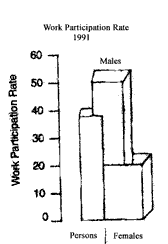
|
| Ans. |
|
| 9.1 |
The work participation rate
of females is the lowest only upto 20 -14 %
approx.
|
| 9.2 |
The work population rate of
males is the highest ( upto 50 - 51.6 % approx.)
Mostly in the tribal areas of the North -
East. |
| Q.10. |
Study the table given below
and answer the questions that follow :
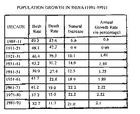
|
| 10.1 |
In which two decades was the
annual growth rate highest ?
|
| 10.2 |
In which decade was the
annual growth rate the lowest ? Give one reason
based on the table.
|
| 10.3 |
In
which decade was the death rate lowest ? What
was its effect on the growth rate in that decade
?
|
| Ans.
|
|
| 10.1 |
In 1961- 71 and 1971 - 81
the annual growth rate was the highest. It was
2.22 % and 2.22 % respectively.
|
| 10.2 |
In 1911-21 the annual growth
rate was the lowest ( it was 0.09 %). It may be
because of decline in population due to large
number of deaths caused by influenza in
1918. |
| 10.3 |
In 1981-91 the death rate
was the lowest. Due to this there was an
increase in the growth rate.
|
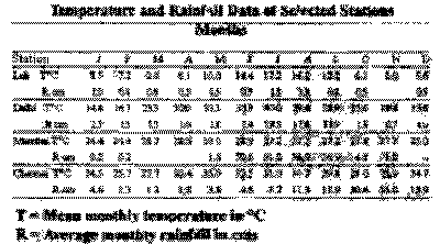
| Q.11. |
Study the temperature and rainfall data of
the four stations as given in the following
table and answer the questions that follow :
|
| 11.1 |
What
is the annual range of temperature at Delhi ?
|
| 11.2 |
Name
the station which receives maximum rainfall
during the retreating monsoon season.
|
| 11.3 |
What
is the annual mean temperature at Leh ?
|
| 11.4 |
Which station receives the highest annual
precipitation
. |
| Ans. |
|
| 11.1 |
The annual range of
temperature at Delhi is 18.9 deg.
C. |
| 11.2 |
Chennai receives maximum
rainfall during the retreating monsoon season.
|
| 11.3 |
The annual mean temperature
at Leh is 5.016 deg. C. |
| 11.4. |
Mumbai receives the highest
annual precipitation . |
| Q.12. |
What
is soil erosion ? Describe three methods to
check soil erosion .
|
| Ans.
|
Soil Erosion in India : - The soil
erosion in India is a great problem. The upper
layer which is fertile is blown away by wind,
water, glacier is called soil erosion. In India
soil erosion takes place in North - East and
North - West region. Following are the causes of
soil erosion : -
|
|
1. Rivers :Rivers make deep
valleys. During the flood the water carries away
fertile soil. Sometimes the river changes its
course and causes much erosion. It is done by
Yamuna and Chambal rivers. 2. Abundant
Rainfall. In India, soil erosion takes
place due to heavy rains. The water erodes the
upper fertile layer of the soil.
3. Slopes : Soil erosion takes place
in hilly regions where slopes are steep. It is
found in East of India.
4. Speed of wind : In Rajasthan and
South - West Punjab soil erosion takes place due
to the wind. The wind erodes the soil when it
blows at high speed.
5. Cutting of vegetation : Where
people cut vegetation for farming, soil erosion
takes place, because vegetation holds the soil
together with the help of roots.
6. Unscientific Agriculture : It also
causes soil erosion. The farmers water their
fields excessively with the result the water
erodes the soil and takes away the fertile soil.
|
| Q.13. |
"The Green Revolution was only the
grain revolution." Write two facts one in
favour and one against this statement along with
a reason for each.
|
| Ans. |
(ii) The importance of Green
Revolution in India's economy cannot be
overestimated because 72 per cent of India's
population depends upon agriculture and 35 % of
India's national income comes from agriculture.
But when all is said in praise of the Green
Revolution India has to import several lakh
tonnes of foodgrains to lay by sizable buffer
stocks against a national emergency. On average
per acre crop yields are still lamentably low
compared to those of the developed countries
like those of Europe, the U.S.A., Canada and
Japan. This is because the fruits of
agricultural research have not yet reached the
poor cultivator and our irrigation means cannaot
maintain assured water supplies to the needy
fields due to the vagaries of India's climate
which is changing from year to year now.
However, the Government is
taking several steps to mitigate the evil of
climatological aberrations.
Firstly, wet agriculture is
carried on in humid areas by checking floods and
annual inundation of cultivated land.
Secondly, forest cover is
not allowed to be removed in areas susceptible
to land sliding.
Thirdly, real forestation is
being done in areas rendered dangerous by unwise
tree-cutting. But the Vana Mahotsava drive of
the government too seems to be short sighted
because the eucalyptus tree has been chosen for
re-afforestation over the great Himalayan
stretch and the plains and deserts of India. But
experience has taught that the eucalyptus is
more a bane than benefit. This tree with
exceptionally long tap roots and tough and
leathery leaves thrives more on underground
water than on atmospheric humidity or the soil
and sub-soil moisture'. AS such detracts rather
than attract rain clouds. Due to this peculiar
characteristic of the eucalyptus tree the
extensive mulgadotted peneplains of Australia
have become either arid or semi arid wastelands.
Hence we should plant eucalyptus trees only to
dry off omersties or check upwelling of water in
populated areas, such as in Shahdara part of
Delhi State.
Fourthly, more and more
irrigation facilities are being offered to the
farmers, though the poor farmers still remain
deprived.
Fifthly, more chemical
fertilizers are being made available to the
farmers.
Sixthly, high yielding
varieties of seeds are being supplied to
increase per acre yields of crops.
Seventhly, barren areas are
being made productive by scientific techniques.
Eightly, soil erosion is
being checked by bruding and contour ploughing
etc.
Ninthly, dug farming
technology is being advanced to areas of paucity
of water resources.
Tenthly, suitable crop
rotation system are being popularised.
Elevently, government is
liberally arranging air spraying and pest
control measures in areas of need.
Twelfthly, soil testing
facilities are being extended to an increasing
number of farmings.
Thirteenthly, scientific
storage facilities and revision of support
prices from year to year is being done to make
agriculture a pursuit of profit. Thus Green
Revolution is vital to the very existence of
India.
|
| Q.14. |
What
changes have been brought about by the Indira
Gandhi Canal in Western Rajathan ? Explain any
four important points.
|
| Ans. |
Four important changes are :
(i) It will irrigate
12.8 lakh hectares of agricultural land, (ii)
many desert land will be turned into green
lands. (iii) Rajasthan will become third major
producer of grains. (iv) Sri Ganganagar, Bikaner
and Jaisalmer now produce wheat sugarcane and
cotton. |
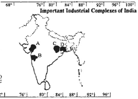
| Q.15. |
Study the following map of India and answer
the questions that follow :
|
| 15.1 |
Name
the industrial regions market as B and D.
|
| 15.2 |
Which major manufacturing industry have
developed in region A ?
|
| 15.3 |
Name
a famous city located in region C.
|
| 15.4 |
Name
one item, manufactured in region D, Which is
very important for export.
|
| Ans. |
|
| 15.1 |
The industrial region marked
as 'B' is Bombay - Pune Industrial Cluster and
'D' is Hoogly Industrial cluster.
|
| 15.2 |
The major manufacturing
industry developed in region 'A' (Ahmedabad -
Vadodra Industrial Region ) is cotton textile
manufacturing
industry. |
| 15.3 |
The famous city located in
region 'C' (Chottanagpur Industrial Cluster)
Jamshedpur.
|
| 15.4 |
On item manufactured in
region 'D' which is very important for export is
-- Paper, Jute leather goods.
|
| Q.16. |
Why
has the Punjab the highest density of roads ?
Explain five factors responsible for the same.
|
| Ans. |
The Punjab is the most
developed and rich state of India. It is
developed agriculturally and industrially. It
has been made possible through railroads and
roads. Roads have played a major role in this
development. Every feeder road is linked with
the main road, every village road linked with
the main road |
| Q.17. |
Describe five favourable conditions for the
development of hydel power in
India. |
| Ans. |
These five favourable
conditions are : |
| (i)
|
Undulating relief presents
ideal conditions for waterfalls.
|
| (ii) |
Construction of dams is easy
and less costly. |
| (iii) |
Reservoirs can easily by
constructed. |
| (iv)
|
Siltation problem is minimum
due to hard stony rocks.
|
| (v)
|
Most of the industries and
other things solemnly depend upon water power as
coal and petroleum regions are far away and
their transport involves huge amounts.
|
| Q.18. |
Write three main objectives of the National
Capital Region development plan. Why are these
objectives still unachieved ? Give two reasons
. |
| Ans. |
The three main objectives of
the National Capital Regional development plan
are :
(a) regulation of
the population so that the quality of life does
not deteriorate. (b) decentralisation of
economic activities away from the metropolis of
Delhi and generally economic opportunities in
the ring towns within the NCR.
(c) decentralisation of
selected government offices and an intergrated
development of infrastructures like transport
network, water supply, power. housing and other
social facilities.
The above objectives are
still unachieved mainly because of increasingly
pollution and population and problems of
sanitation, Sewage disposal and congestion.
|
| Q.19. |
In
the outline map of INDIA supplied to you mark
and label the following at the appropriate
locations :
|
| 19.1 |
River Damodar;
|
| 19.2 |
Capital of Assam
: |
| 19.3 |
Punjab |
| 19.4 |
Kandla |
| 19.5 |
M.P. |
| Ans. |
|
| 19.1 |
River
Damodar |
| 19.2 |
Guwahati
|
| 19.3 |
Punjab |
| 19.4 |
Kandla |
| 19.5 |
M.P. |
| Q.20. |
For
Blind Students only ( In lieu of Q. Nos. 7,9,15
and 19). |
| 20.1 |
Name
: |
| (a) |
The
mineral for which Bailadila mines are
famous. |
| (b) |
Particular trade in which Parja tribal
people are skilled.
|
| (c)
|
The
tribe that inhabits in Abhujmar hills.
|
| 20.2 |
|
| (a)
|
Why
is participation rate of males more than that of
females in India ? Give one reason.
|
| (b)
|
What is the participation
rate of females in India ?
|
| Ans.
|
20.1 (a) Iron
Ores |
| (b) |
Fisheries
|
| (c) |
Abhujmaria tribes of Bastar
|
| 20.2 |
|
| (a) |
Because of literacy or lack
of literacy. |
| (b) |
20.2
%. |
